Maps


Maps
Maps
Member Benefits
 30% Off All Books - Savings that support storytellers, not stock prices.
 Fight Book Bans - Every membership sends a book to LGBTQ+ youth in affected states.


Member Book Price
$37.99
$26.59
Couldn't load pickup availability
Description
Description
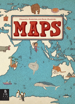
Travel the world without leaving your living room. This book of maps is a visual feast for readers of all ages, with lavishly drawn illustrations from the incomparable Mizielinskis. It features not only borders, cities, rivers, and peaks, but also places of historical and cultural interest, eminent personalities, iconic animals and plants, cultural events, and many more fascinating facts associated with every region of our planet.
About the Author
About the Author
Aleksandra Mizielin´ ska and Daniel Mizielin´ ski graduated from the Academy of Fine Arts in Warsaw, Poland, in 2007. In 2010 they were nominated for the Bologna Ragazzi Award and the IBBY Honor List.
Critical Reviews
Critical Reviews
[F]eatures playful line drawings of national and geographical attributes, including famous native folk (Freud, Kandinsky, Count Dracula). ... [A]n entertaining and informative choice for budding geographers or Eurail travelers-to-be.
--The New York Times Book Review [A] delight to explore, as the Mizielinskis fill their maps with tiny labeled images of local wildlife, cuisine, activities, and notable citizens... Compelling.
--Publishers Weekly Handsomely detailed illustrations include major industries, regional insects, birds, fish, and other animals, plants, crops and prepared food, and famous people. ... This book supports and encourages geographic literacy.
--Library Media Connection (highly recommended) [R]ewarding fare ... for both young cartografiends and armchair travelers.
--Kirkus Reviews This handsome and fun-to-browse volume will inspire armchair travelers. ... The artwork's muted earth tones, decorative borders, and fine-lined drawings are reminiscent of an antique rendering, while the numerous small cartoon illustrations add a light, contemporary touch. ... [W]insome renderings.
--School Library Journal At once a celebration of diversity and an investigation of the natural and cultural offerings that make each country unique, this expansive and impressive book of maps ... is richly detailed with dozens of extraordinary drawings... Hours of fascinating perusal await.
--Foreword Reviews There is no dearth of atlases for children, but Aleksandra and Daniel Mizielinski's "Maps" is a standout. ... [The authors'] enthusiasm and love for facts kids might want to know shine forth in charming little illustrations.
--Newsday [A] sumptuous illustrated children's atlas that combines chic, muted colors with witty and informative drawings on heavy matte paper that whispers under the fingers. ... The sort of book you can't help touching, "Maps" is as likely to engross adults as it is 7- to 10-year-olds. ... [I]t gives aesthetic pleasure all the way from the table of contents to the flags of the world at book's end.
--The Wall Street Journal [A] nonfiction visual feast... [G]loriously portrays the world's profusion of creatures, mountains and man-made structures in chic, subdued shades of beige, mauve and eau de Nil.
--The Wall Street Journal A visual extravaganza with fascinating trivia in pages as spacious and luxurious as a classic road atlas. It's an invitation to travel around the world one page at a time. ... "Maps" is a treat, with its richness of details catering to young readers in this electronic age who thrive on all kinds of visual stimuli. This book will also appeal to other members of the family. All will scour for details and trivia as obscure, fun and varied as where one might sandboard or see a yak.
--Shelf Awareness for Readers Along with geographical features and pictures, you'll find amusing depictions of indigenous animals, native dress and characteristic architecture... Between the buildings, food and history, the maps will awaken a wanderlust for unfamiliar and exotic locale.
--Metro Philadelphia Not exactly your library's world atlas. These maps, illustrated in distinctive style by the authors, denote the culture and history of a place rather than its exact coordinates.
--Entertainment Weekly
Publishing Information
Publishing Information
Publisher:
Big Picture Press
Pub date:
2013-10-08
Length:
112 pages
The Allstora Membership
Membership Perks:
- Save 30% on all online store purchases
- Exclusive access to author's content
- You pay less, but authors still earn double
Membership Terms:
First Month:
$0.00
Monthly price:
$5.00
- To access membership discount simply log in and add to cart, discount applied automatically.
- One month free trial, cancel anytime. Membership renews on the 15th of each month.